

Thursday, October 15, 2015
Back on the road.
Thursday, June 4, 2015
Wednesday, June 3, 2015
The Fog of the 400
By Capn John Ende
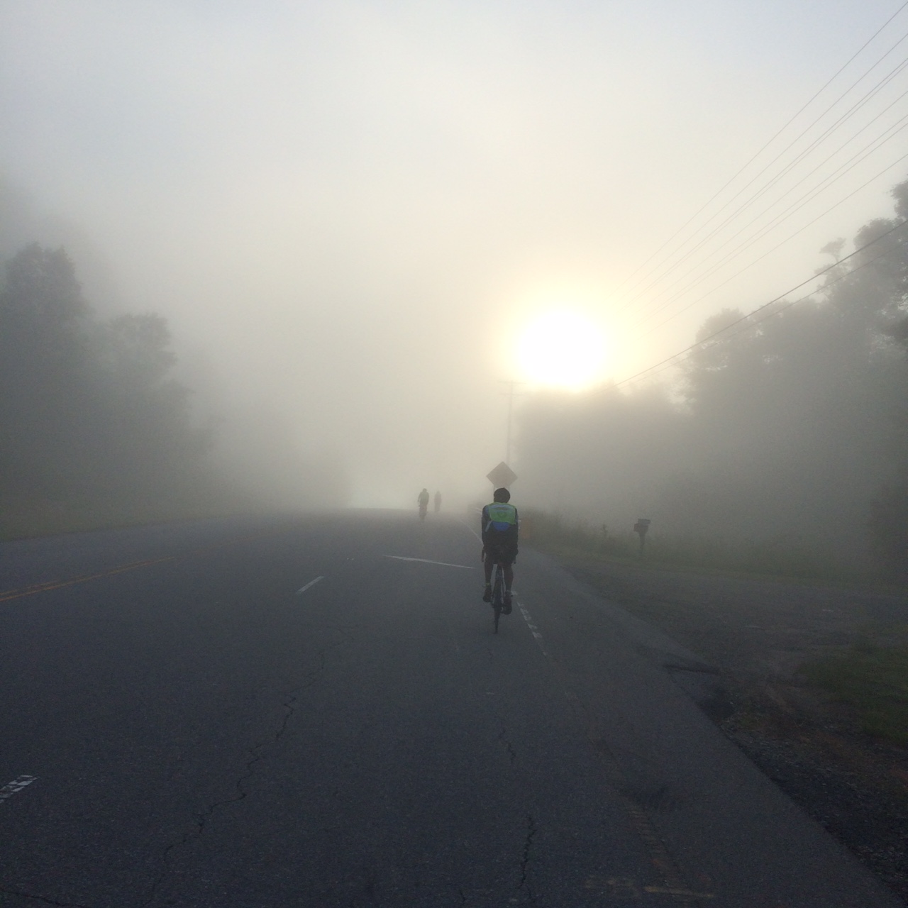
Nine riders set off into the early morning fog. Nearly a full day later the same nine finished in a very different early morning fog. The inaugural running of the Asheville/Damascus/Asheville 3 state 400k (255 miles) chose one of those perfect days for a long ride. Just a little warm in the sun. Just a little cool in the shade. Little fluffy clouds punctuated an otherwise Carolina blue sky. A slight breeze cooled the peloton on the many climbs and never impeded progress. Despite the many sharp edges of the elevation profile and 18,431ft of climbing riders came from as far away as Washington DC and south Georgia.
The course did not disappoint those traveling efforts. Four sustained climbs broke up some really enjoyable quiet valley riding. The route out followed the French Broad River into Marshall where the climbing began. We made our way through the East Fork area and up and over Grapevine.
 |
| The glamorous life. |
Have you ever seen the twists and turns of a grapevine? You'll know how they came up with the name of the road then.
Big Laurel was the cut over to Sam's Gap and after the up and over into Tennessee it was time to fight over the last three remaining tin foiled wrapped pork tenderloin biscuits in a gas station counter warmer.
With food in our bellies we continued to the North East eventually climbing up and over the Appalachian Trail into Shady Valley. Shady Valley was bucolic 1-2% downhill all the way into our turnaround at Damascus VA.
Nearing Damascus we unknowingly crossed the poorly marked VA state line. We also passed through the impressive dominant natural rock wall formation known as the "backbone." The road passes directly through a cut in the rock.
 |
| The Backbone... |
 |
| A little sun in Shady Valley |
Damascus is a beehive of bicycles as it serves as a popular home base for the many tourists coming to ride the Virginia Creeper Trail.
We grabbed a much-needed sit down meal at a local grill and began the journey for home.
The long slight downhill into Damascus turned into a long slight uphill where we contemplated retracing most of the route back to Asheville that included a very stiff challenge back up to Sam's gap. It turned out that the slight uphill through Shady Valley could be ridden in the 12-14mph range and the long challenging climb up to the AT in the midday sun was now not nearly as bad from the north in the later afternoon. Seven riders scattered into 4 different restaurants in Johnson City TN while two pushed on. This section was new to us, as we had not seen it on the way out. We donned reflective gear and were introduced to one of those spiky bits on the profile as owls hooted encouragement.
A quick fill of the bidons in an Erwin McDonalds and we were ready for Sam's Gap. In the next 18mi we would gain 2,000ft. Ouch! We settled into our rhythm and all climbed together in the dark until we sat at the top of the last major climb of the ride. Relief! With our packed sleighs we flew down Mt. Crumpet into Who Ville, wait a minute, different story, same idea though.
Our next target was a Waffle House control in Mars Hill. We entered with a powerful hunger. Unfortunately we walked out 30 minutes later in the same state having had nothing more than chocolate milk, water and a coffee. The staff has been working through some issues. It seems that the cook has been recently overwhelmed when too many orders are placed at the same time. So now orders line up like planes at a busy airport patiently waiting for their turn to be called out and prepared. Our patience ran out and after two of our counter-sleeping compatriots were roused we rolled out with sloshing bellies of liquid concoction. This is where a few of us started to feel a bit nauseous. Eventually we all made it safely home just shy of 24 hours and all within 40 minutes of each other.
Sloppy Joes were served at the Luke Heller's house and a few brief stories ensued before the sandman came for us. Thank you to Luke Heller for planning the route and putting on the ride. It was the most scenic and challenging 400 that this rider has seen. Chapeau to all who finished!

Friday, December 19, 2014
2015 Riding Goal? How About Charly Miller AND Adrian Hands Society!
By Cap'n John Ende
 |
| Cap'n Ende |
I'm no PBP expert but I have completed three and I really
love the event. I hope to be lining up with 5,000 or so of my closest friends
this coming August. Dreams lead to plans. I'm sure others are planning their
PBPs. I like the formula we fell into last go around and hope to use it again. Stop
pretty much everywhere that has food and see how things go. My target was a
finishing time beyond 88:55 but alas came in a wee too fast. No worries, there's
always the next ride.
I was hoping to post a qualifying time for la Société Adrian
Hands. To gain admittance one must complete PBP in a time of 88:55 or greater. This
is the time that Adrian Hands established by completing PBP in 2003. One
hundred and two years earlier Charly Miller entered his 56:40 into the Great
Book. To gain entry into la Société Charly Miller one must complete PBP in
56:40 or less, and be an American.
As expected, a quick inventory of the membership of each
group shows no overlap. The societies are polar opposites of one another. There
is no rider in la Société Charly Miller and la Société Adrian Hands. Charly
Miller is for the fastest of the fast. Adrian Hands is for the more
chronologically relaxed. Charly Miller is for American riders. Adrian Hands
accepts riders of any nation. Both societies agree that PBP is a necessary rite
of passage. Since qualification occurs during a very well attended event,
eventually someone will belong to both groups.
 |
| Adrian Hands at the finish of PBP 2003... |
I'm sure there will be no argument when I propose that it is
more difficult to gain entry into la Société Charly Miller. The list only
numbers 45 qualified riders as compared to 78 for la Société Adrian Hands. The
first dual citizen will likely come from the Charly Miller list but that is not
a given. In 2011 LSAH member Branson Kimball attempted a Charly Miller time on
a fixed gear. He came up short on that particular ride but he is definitely
capable of a very fast time. Perhaps with gears he could be the first. I heard
that Tim Bol a Charly Miller member was looking for a more relaxed ride in
2011. He posted an 88:51. The clock can be cruel. I don't know his intentions
but he obviously has the palmares to be the first on both lists. An LSAH rider
who has a legitimate chance in 2015 is Bill Russell. He gained Hands entry with
his 89:17 in 2011 but since then has switched to a velo mobile and has been in
the habit lately of posting very fast brevet times. Control opening times
figure more into his ride plans then closing times. Perhaps 2011 Charly Miller
inductee Bob Brudvik will decide to sample the local fare with his new riding
buddies from NC and join la Société Adrian Hands in 2015. Of course lining up
at a start time other than the 90 hr one prohibits a chance for entry into
LSAH.
I have the great pleasure to ride with some very good riders
that are on neither list but could be on both. Mike Dayton, Mark Thomas and Dan
Driscoll come to mind. They have the engines to go fast but the attitudes to
take it easy. As Mark likes to say, "we'll start off slowly and back off
from there." That is the kind of mantra that posts an 88:55 plus. The last
person that I might mention as a strong possibility for both Charly Miller and
Adrian Hands has it in his bloodline, Ian Hands. In 2011 he recorded a perfect
88:55. I wouldn't be surprised to see him post a 56:40 sometime. He has it in
his legs, although he might not have the desire to race through PBP. Not enough
time to meet everyone. Ian, you could always finish fast and then ride back out
onto the course to ride in with your buds. Look for us at a café.
When we will have the same name on both lists? My guess is
2015. Let's all go to Paris just in case this is the year. Wouldn't want to
miss that.
Thursday, November 20, 2014
Subscribe to:
Posts (Atom)