Sunday, August 24, 2008

Route Scouting: Showdown at Black Creek or Who's Your Daddysville

Do we ever get tired of talking about PBP?

Apparently not. That celebrated randonneuring event is just too big, too life-altering. Do it once and it's forever burned into the DVD of your memory, cued up for replay anytime two or more anciens gather for a ride.

And so it was Saturday when Branson, Byron and I tested a route I'm preparing for an October brevet. (I'll call it "Showdown at Black Creek," because it has a nice western sound, like a John Wayne cowboy movie. But the first alternate could be "Who's Your Daddysville" since we cut right through that crossroads community.)


View Larger Map

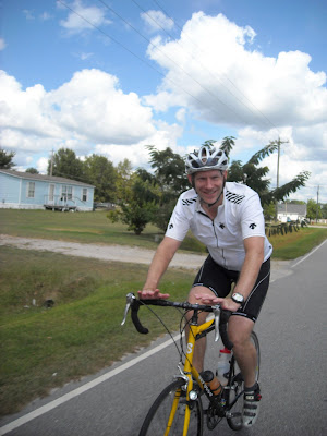
We gathered Saturday morning at the parking lot of Wakefield High School in North Raleigh.

Byron and I were both wearing our PBP '07 jerseys. Coincidence? Well, yeah, but Branson later surmised some bigger forces might have been at work since exactly a year ago we were on the PBP course, suffering through the rain and the cold and the hills.


Under the big clouds of eastern North Carolina, we mentally relived the rolling hills into Villaines and Mortagne, the speed-run to Dreux. But there were very few hills on yesterday's course, which largely followed state Bike Route 2 before switching off to Bike Route 7 northwest of Wilson and angling south to Black Creek. The route is often signed as a bike route, making navigation fairly easy. The roads were exceedingly quiet, with the exception of Thompson Mill about 5 miles from the start and 3 or 4 miles of Tarboro Road around Youngsville, also near the start.


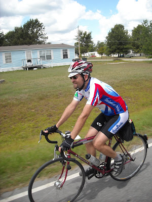
Here are the boys rolling along on one of the many quiet stretches of back road.

The ride is being planned as part of an effort to travel the state's Mountain to Sea Trail in October. Land is still being acquired east of Raleigh for a true hiking trail, so it currently follows the bike routes. This effort is being coordinated by friend Kate Dixon, the executive director of the Friends of the Mountain to Sea Trail. She's married to randonneuring buddy Dan Wilkinson.

Kate drew out the route for me in the N.C. topo map book. I generated a cue sheet in about 15 minutes using Google's new "Walking Directions" and a program Branson found. See this post for more info.

The mileage on the cue sheet was right on the money, but occasionally Google had trouble when the road crossed a county line and changed names. Google would put in an extra direction or two that, while not wrong, was confusing. Once we had to stop and decide whether we were still on course. We were. Also, Google does not put in confirmation points -- for instance, it makes no mention of crossing a major road. But these minor quibbles were easy to fix in the shake-out ride.

We passed multiple country stores, noting all of them and taking advantage of several for water and fuel. Running out of water should not be an issue on this route.


Here's one we stopped at on the way down. It's at 40 miles and I may use it as a control. It used to have a grill but I'm not sure it's fired up these days. However, there were plenty of food options.


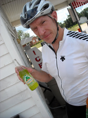
Speaking of options, with a growing Latino population in eastern North Carolina, we now have some new drink choices.

We picked up two riders along the way -- a guy named Jeff who let us know he was very competitive, it was his nature in everything he did, before riding off the front.


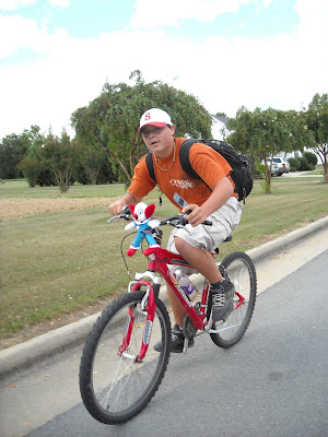
Just outside Black Creek we picked up a kid riding into town for a sleepover with a pal. He had a 40-pound pack on his back and a Bozo strapped to the front. He also had a competitive streak and hung with us for a couple miles.


View Larger Map
When we hit Black Creek, the odometer read right at 62 miles -- hmm, this might be a perfect 200k.

The Wilson County municipality of Black Creek is closer to a ghost town than an ongoing enterprise. At one time the railroad must have been the town's lifeline -- it literally slices the place in two, dividing East Center Street and West Center Street. But the railroad doesn't stop there any more. Not much stops there anymore. There are a dozen old storefronts along the two Center Streets, but only one or two appear to be up and running as a business.


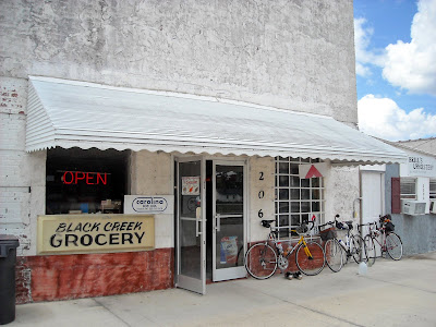
Luckily, the Black Creek Grocery is open -- "8 to 8" -- Mickey the proprietor told us. His family has owned the store since 1979. We bought a gallon of chilled water, chips and sandwiches. Byron heated his sandwich in the microwave until "it was 1,000 degrees on the bottom but still frozen on top."


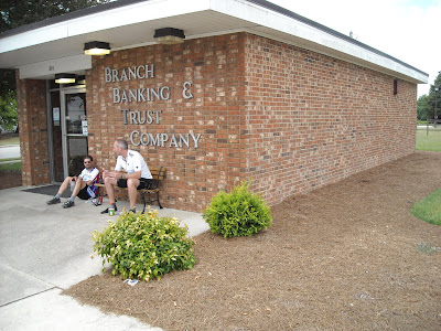
We ate lunch on the only seat in town -- the bench in front of the BB&T bank -- before heading back around 1 p.m. for the second 100k. Any legs I'd had on trip down must have taken the bus home. On the homeward journey I relied on the kindness of Byron and Branson to break wind, but in a good way.

After so much flat riding, it was almost a relief to get back in a few hills around Youngsville.


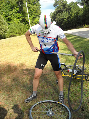
Speaking of flats, Byron had one about 5 miles from the finish but got it repaired in no time flat. We finished up a few minutes after 5.

All in all a great day on the bikes, topped off by a pizzas at Rudinos, where we were joined by Maxi.

Here's the map in EveryTrail, after being dumped from my GPS.

Showdown at Black Creek

Widget powered by EveryTrail: GPS Geotagging

Friday, August 22, 2008

Stopping to Smell Flowers, Eat Berries, and Watch Dinosaur Birds, by D. Furbish


The first week of August, I had the opportunity of cycling over 300 miles of rails-to-trails in Wisconsin. Wisconsin has an extensive rails-to-trails system with several trails near Madison, alone. My brother and I chose to ride two trails we had not yet ridden: Badger State Trail and Glacial Drumlin State Trail.


While portions of the trails are sometimes paved, most miles consist of firmly packed crushed limestone wide enough for four-wheel patrol vehicles. The surfaces were suitable not only for my 700 x 32 tires but for the even skinnier tires of two tri-athletes who passed us one day headed in the opposite direction.


Trail passes are required in Wisconsin and can be purchased at trail heads and at businesses in the towns along the route. I purchased a $20 annual pass, in part, a donation to a worthy cause. (Daily passes are $4.) Park rangers stopped me on two separate occasions to check my pass. The trails are well utilized by cyclists, walkers, and joggers, but definitely not crowded. There were cyclists on the trails even on week days.


We couldn't have asked for better weather. The sunny days were cool with lows in the mid-50s and highs in the low to mid-80s. Did I mention low humidity? Although it never rained, the usual threat of afternoon showers provided protection against the sun. Below are wildflowers in the foreground and one of many glacial drumlins of southern Wisconsin in the distance.


The Badger State Trail begins at the outskirts of Madison and extends south to the Wisconsin border where it joins the Jane Addams trail. The latter is part of the 500-mile Grand Illinois Trail. Bill and I rode a 90-mile out-and-back chunk that started just south of Madison extending into Illinois. We passed through several scenic towns: Belleville, Monroe, Orangeville. Along the way, we compiled a mental list of eateries that might provide a suitable lunch stop on the return leg.


I switched on my helmet light when we came to an old railroad tunnel that required lighting. The temperature inside the tunnel was easily ten degrees cooler than outside. There was a misty shroud inside the tunnel adding to the make-believe eeriness. A real troll pretending to be a "cyclist" guards the entrance.


The railroad bed cuts through limestone embankments, crosses numerous creeks, and is generally sheltered by a cool, green canopy of poplars, maples, oaks, ashes. The trail was festooned with wildflowers: pink and yellow coneflowers, pink bee balm, milkweed, and Queen Anne's Lace. Now we were riding through a wooded valley alongside a stream, now we were riding a ridgeline with a panoramic view of checkerboard fields of dairy farms below.


Bill spotted a mulberry tree whose limbs full of ripe berries extended to the trail's edge. It was time to stop. We helped ourselves to the sweet treats. Fortified with antioxidants, we continued our quest. I'd learned long ago that when I saw acorns on the ground, I expected to see an oak tree above. Similarly, little dark spots on the trail meant mulberries hanging overhead!


Chipmunks (ground squirrels) were out in force. We saw hundreds of these storybook creatures on and alongside the trails, engaging us in a game of cat-and-mouse, scurrying away at the very last second.


Our second long ride of the week was another out-and-back, this time on the Glacial Drumlin State Trail, which extends eastward from Cottage Grove (near Madison) to Waukesha (near Milwaukee). We included a brief side excursion to Aztalan State Park, an important archeological site inhabited 700-1000 years ago.


My brother is a true randonneur: he looks upon the opportunity of riding as one and the same as an opportunity for eating. We had made good time. So we were justified in our relaxed, late-afternoon lunch in Sullivan, WI, at Jamie's where we'd been told was the best best food in town and the Milwaukee Brewers were on TV.


The glacial drumlin trail is relatively flat. It is protected for the most part by a canopy of trees. There are exposed portions through marshlands that serve as bird sanctuaries. I saw ducks, geese, herons, and Sandhill cranes. The latter are interesting birds. The first time I saw one of these magnificent birds, I had no idea what it was. It looked like a brown ostrich or a mythical giant, long-legged kiwi. The Sandhill crane is unique. In fact, according to experts, it is the oldest known bird species still living! A dinosaur bird? Not quite. But this is as close as it comes. Time once again to stop and look.


Randonneuring in the News

Yo Adrian, the source for all things cycling, sent along these links to two randonneuring stories.

The first is a good overview of the sport by 3x Ancien Gary Koenig. It's here.

The second article chronicles the attempt by Spencer Klaassen and Dan Clinkinbeard to ride RUSA's longest permanent. They start their journey this Sunday.

Wednesday, August 20, 2008

Two New Great Tools for Creating Maps & Cue Sheets


Things happen fast on the Internet, don't they? I've been working on a new brevet/permanent route from North Raleigh to New Bern. That route was chosen to track NC's Mountain to Sea Trail, which currently uses bike routes as it travels east of Raleigh. Friend Kate Dixon, the executive director of the Friends of the Mountain to Sea Trails, is trying to have all 935 miles of the trail covered in October. I've agreed to help with a cycling effort.

But back to the maps and cue sheets. Kate gave me a topo map book where she'd traced out the route. It was easy to convert that into a fixed electronic map and somewaht usable cue sheet, thanks to changes in Google Maps and a program that Branson found. Here's how.

First, I went into Google Maps and set directions from North Raleigh to New Bern. Then I set Google Maps to "Walking Directions." Voila! Google actually routed on many of the roads I'd picked for my Blackbeard Permanent. I used the "drag map" feature to pull the route onto the roads that Kate had selected.

Unfortunately, Google maps must have some limit on the number of map drags you can do. That forced me to split the map into two segments: 1) North Raleigh to La Grange and 2) La Grange to New Bern.

Next, once the map was created in Google Maps, I used the information on this site to generate a cue sheet. All you have to do is click on that bookmark after you've created the map.

Here's the cue sheet from No. Raleigh to La Grange (the spacing among the columns is gone, but you get the idea):


Route: Wakefield Pines Dr to La Grange, N Carolina

Distance: 91.94 miles

Total Distance Directions

----------------------------------------------------

0.00 0.00 Depart from: Wakefield Pines Dr

0.11 0.11 Right: Falls of Neuse Rd

1.60 1.49 Bear Right: Old NC 98 Hwy

1.76 0.16 Left: Thompson Mill Rd

4.72 2.96 Bear Right: Bud Smith Rd

4.79 0.08 Right: Purnell Rd

6.10 1.30 Left: Jackson Rd

7.67 1.57 Right: Holden Rd

9.94 2.27 Straight: NC-1147

11.03 1.09 Straight: Main St

11.80 0.77 Straight: Tarboro Rd

18.72 6.92 Left: NC-98

20.75 2.02 Right: Strickland Rd

22.61 1.86 Left: Old Halifax Rd

23.91 1.30 Straight: Medlin a Ln

24.08 0.18 Straight: Brantleytown Rd

25.95 1.86 Right: NC-39

26.12 0.17 Left: Pine Ridge Rd

28.85 2.73 Straight: Daddysville Rd

29.02 0.17 Left: Old US-64

30.14 1.12 Right: Sanders Rd

30.41 0.27 Straight: Frazier Rd

37.83 7.42 Left: Strickland Rd

41.83 4.00 Right: W Hornes Church Rd

45.91 4.08 Right: Old Bailey Hwy

46.71 0.80 Straight: Lamm Rd

52.99 6.28 Straight: Quaker Rd

54.23 1.24 Left: Downing Rd

54.96 0.73 Right: Shirley Rd

55.69 0.73 Right: Wiggins Mill Rd

56.14 0.45 Left: Boswellville Rd

57.98 1.84 Straight: Lely Rd

58.60 0.62 Straight: Wellons Ct

59.54 0.94 Left: Blalock Rd

60.78 1.24 Right: US-117 Alt

60.85 0.08 Left: Church Loop N

61.65 0.79 Left: Central Ave

61.84 0.19 Right: Mercer St

62.17 0.33 Left: Cemetery St

62.38 0.21 Straight: NC-1628/Woodbridge Rd

63.06 0.68 Right: Frank Price Church Rd

66.33 3.27 Straight: Black Creek Rd NE

66.44 0.11 Left: Aycock Church Rd NE

68.24 1.80 Left: Davis Mill Rd NE

69.17 0.93 Right: Turner Swamp Rd NE

70.94 1.77 Straight: N Church St NE

71.74 0.79 Straight: Faro Rd NE

75.75 4.01 Straight: Old NC-1201

77.02 1.27 Straight: Bullhead Rd

77.26 0.24 Left: Saulston Rd

77.33 0.07 Right: Davis Grove Church Rd

78.46 1.13 Left: Cow Branch Rd

79.35 0.89 Right: Edmundson Rd

81.32 1.96 Straight: Creech Rd/Free Gospel Rd

83.90 2.58 Left: Titus Mewborn Rd

84.98 1.08 Right: Mewborn Church Rd

85.26 0.28 Bear Right: NC-903

91.94 6.69 Arrive at: La Grange, N Carolina

Finally, the cue sheet generator also has a function to add the map to Bikely, which is the map you see at the top of this post.

Saturday, August 16, 2008

RUSA 10th Anniversary Ride Picnic


Post-ride photos.

RUSA 10th Anniversary Ride


What a great day for a ride!

RUSA's 10th Anniversary celebration kicks off this morning with rides taking place across the country.

Here in N.C., we had 34 riders show up for our 200K, which rolled out of the Morrisville parking lot at 6 this morning. A 110K populaire gets going at 10. Riders from both events should finish up at around the same time, and a picnic is planned at Morrisville's Community Park.

I pre-rode with Chuck and Branson last Saturday so I could practice my short-order cook skills today. I set the alarm early so I could see everybody off this morning. Lots of familiar faces were at the start, including: Glenn from Virginia, who I hadn't seen since Dinge on last year's PBP; Shenandoah vets Lin and Jon; Paul from Charlotte; locals Jerry, Branson, Dean, Wes, JoAnn, Byron, John, Gregg, Mike, Paul, Gary & Sara; and new faces including Vance from Greensboro and some names I did not catch. And of course: Fearless Leader Al and his lovely bride.

I'm one of the first on the Web with shots of RUSA's anniversary celebration, but you're likely to see hundreds more photos nationwide as ride reports from about 25 events begin to roll in.

Let the fun begin!

Monday, August 11, 2008

200K Morrisville NC Pre-Ride


Next Saturday is RUSA's 10th anniversary, and Fearless Leader Al has two rides planned -- a 200K brevet and a 110K populaire -- as well as a picnic at the finish. Three of us, myself, Branson and Chuck, have agreed to help out on the Big Day, so we took advantage of RUSA's pre-ride rule to complete the 200K last Saturday.

The weather was tailor-made, especially for August -- low humidity and high temperatures in the mid 80s made it feel more like late September, and cloud cover kept us relatively cool for most of day. By the afternoon, however, it felt like summertime.

Steel was the ride of choice with two Cohos and Branson's Serotta. We picked up a hitchhiker about 25 miles in. A rider named Greg saw us passing by as he rolled out of his driveway on Mann's Chapel and hung with us until the turnaround at Siler City, where he took a shortcut home by following Hwy 64E back to Pittsboro.

The company and pace were both exceedingly pleasant. At times we flat out lollygagged. I made the boys offer up opinions on the John Edwards story, as that titillating scandal was still fresh news.

After a fairly slack schedule this spring, I finally got good miles in during July, and on Saturday's ride I felt just about back to normal and pushed the pace a few times toward the end of the day. We finished in just over 8 hours, not bad for a ride without any focus other than fun and friendship. At the finish we got a sneak preview of some freshly minted 10th anniversary medals that RUSA made for next weekend's events. Very nice!

Chuck headed back to Randolph County for a church social featuring homemade ice cream while Branson and I ducked into Salsa Fresh for tacos.

Next Saturday, we'll trade the helmets for chef hats and play short order cooks as riders return from the two scheduled rides. At least 20 riders have already signed on. Should be fun. Come on out for the celebration.

Thursday, August 7, 2008

Bicycle Pedals Recalled by Look Cycle; Pedals Can Break Causing Cyclists to Fall

Here's a note on Look Pedals from our friends at CPSC.

WASHINGTON, D.C. - The U.S. Consumer Product Safety Commission, in cooperation with the firm named below, today announced a voluntary recall of the following consumer product. Consumers should stop using recalled products immediately unless otherwise instructed.

Name of Product: KéO Bicycle Pedals

Units: About 80,000 (40,000 pairs)

Distributor: Look Cycle USA, of San Jose, Calif.

Hazard: The steel axle inside the pedal can break, posing a fall hazard to cyclists.

Incidents/Injuries: Look Cycle has received 14 reports of incidents with broken pedals, including 7 injuries which resulted in scrapes, cuts, contusions, elbow pain, and a knee injury.

Description: The recalled bicycle pedals were sold separately from bicycles. Pedal models include KĂ©O Classic, KĂ©O Sprint, KĂ©O HM and KĂ©O Carbon. The model name is printed in white on the side of the pedal. Date codes between January 2004 and December 2005 are included in this recall. The date code for the KĂ©O Classic, Sprint and Carbon pedals is on a dial stamped onto the pedal. The date code for the KĂ©O HM is on the bottom of the pedal, with the letters A through L corresponding to the month, and the numbers 4 and 5 indicating 2004 or 2005. “Ti” pedals are not included in this recall.

Sold at: Specialty bicycle retailers nationwide from January 2004 through July 2007 for between $100 and $500.

Manufactured in: France

Remedy: Consumers should immediately stop using the recalled bicycle pedals and return them to any authorized Look Cycle dealer, or contact Look Cycle USA to arrange for shipping and free repair.

Consumer Contact: For additional information, contact Look Cycle USA toll-free at (866) 430-5665 between 8 a.m. and 5 p.m. PT Monday through Friday, visit the firm’s Web site at www.lookcycle-usa.com, or email the firm at KeoUpgrade@lookcycle-usa.com.